 |
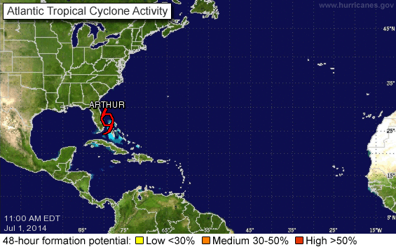
| From National Hurricane Center. |
Beginning June 1, I have started each day with a check of the National Hurricane Center web site and spaghetti models.com. And every day the graphic showed No Tropical Cyclones, music to my eyes. Last year, our first named storm formed the third week of May, before the calendar start of hurricane season. This year, all quiet on the ocean front for the entire month of June, but now...
As of today, we have our first named storm of the season. TS Arthur. Because there is no motion with Arthur now, the track is difficult to predict accurately. Nonetheless, the forecast models are very much in agreement that Arthur will track closely up the southeast coast until it becomes a Cat 1 hurricane and collides, as hurricanes often do, with the capes of North Carolina. As of today, Arthur is expected to increase to hurricane force as it reaches Cape Lookout in the wee hours of Friday morning. Depending on the extent of the wind field, we could feel hurricane force winds; we are only thirty miles from Cape Lookout. Ironically, if I decide to take the boat to a hurricane hole up South River, I would be almost ten miles closer to Cape Lookout, ten miles closer to the eye of the storm.
So, the prep begins with the casual securing of loose gear, thinking through potential problems, making lists, charging batteries. In the meantime, the weather has been excellent the past few days: bright sun, good breezes.
Stay tuned.
How did Wild Haggis (and Jim and Beth) fare during Arthur?
ReplyDeleteNo damage. Little sleep. Full tale soon.
Delete